Hello. My name is Stephen, and I’m the founder of Tours by Foot, a walking tour company, and welcome to this free, self-guided walking tour.
In this post, I take you on a walking tour along a part of route that the Berlin Wall once ran.
The Berlin Wall was approximately 140 km (87 mi.) in length, but only about ½ of it actually separated East from West Berlin.
And I take you along just a small fraction of this part of the wall, from the Hauptbanhof to Checkpoint Charlie.
And, while the focus of this route is the Berlin Wall and the city’s split, this route is a good option for a self-guided tour because it also incorporates many other popular attractions.
You could also see my video tour of this route below.
Be sure to check out my channel full of videos covering Berlin walks and attractions
And, my contact details will be there as well, if you would like to hire me or one of my colleagues for a guided walk here in Berlin.
So, without further ado, let’s get started.
HUMBOLTHAFEN
Humbolhafen connects the River Spree, which is behind me with the canals to Spandau, a western district of the city.
The border between East and West Berlin was frequently defined by water.
And for approximately 30 years, the Berlin Wall butted up to the river to the right side.
The buildings on the right were not here at the time.
What today is Berlin’s main train station was West Berlin, then still mostly wasteland following WW2.
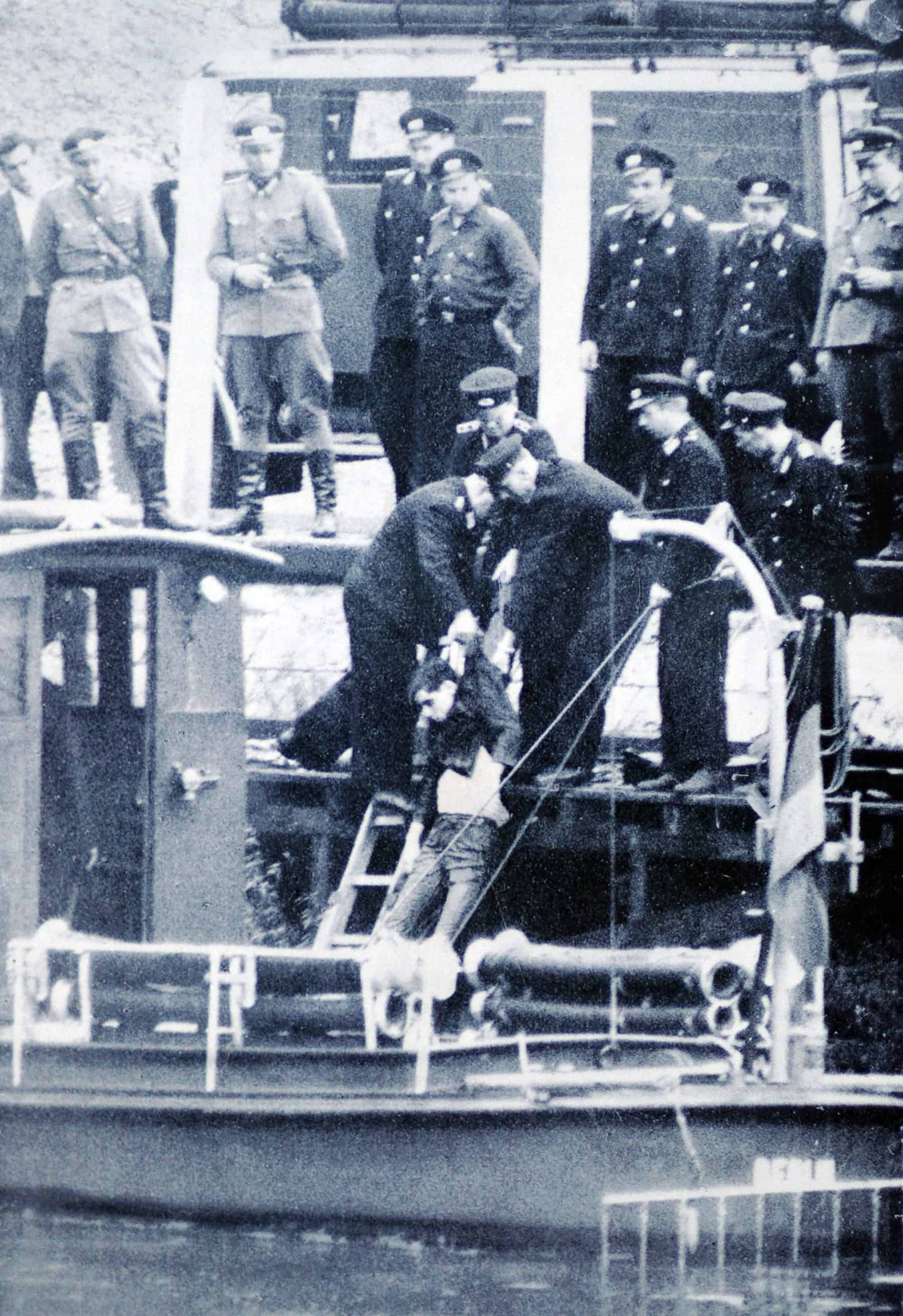
On a sad note, the first victim, at least delibrate victim, met his death here, just 12 days after the border closed.
Guenter Litfin, a 24 year-old tailor who lived in the East but worked in the West, attempted to swim across to the British Sector.
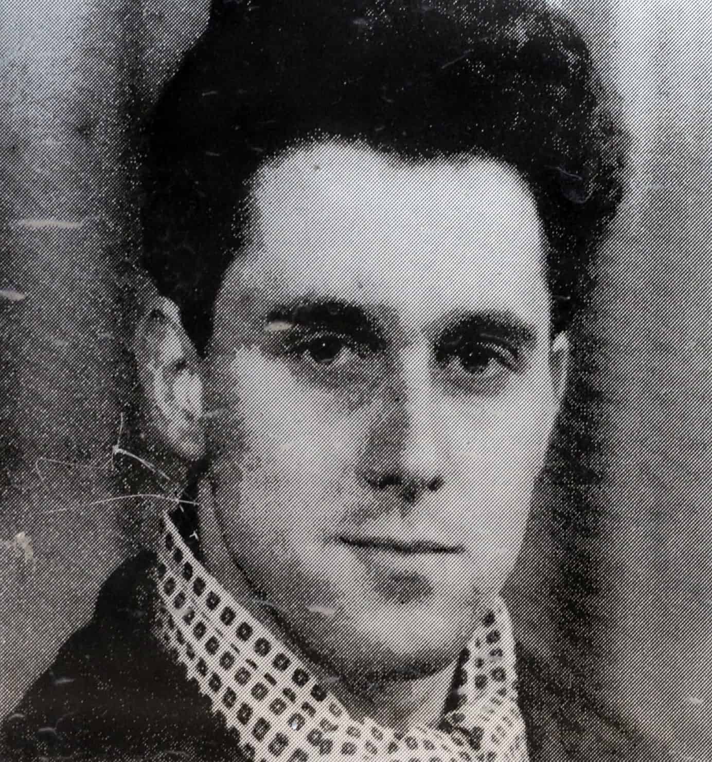
However, he would be gunned down by East German border guard machine guns.
Interestingly, the two transport officers who killed Litfin would stand trial in 1997 and be found guilty of manslaughter and given suspended sentences.
More on the victims of the wall in just a bit.
Moving on.
Wall Ground Markings (ampel man)
Along much of the route of the Berlin Wall, you will find this double row of cobblestones.
In this case, it’s marking the trail of the outerwall, the wall closest to West Berlin.
The barrier for most of its existance consisted of an inner wall, facing East Berlin, as well as the outer wall.
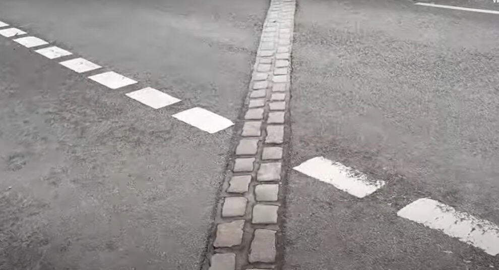
Over time, guard towers, electrified signal fences, anti-vehicle barriers, and other elements were added to the barrier as reinforcements.
And it’s the rather late update of the outer wall design that has become the symbol and image of the Berlin Wall.
Paul Loeb House
The building on the opposite side of the Spree is the Paul Loeb House.
It houses the committee offices of the German parliament, the Bundestag.
On this side of the river is the Marie-Elisabeth Lüders Building, which houses the library of the Bundestag.
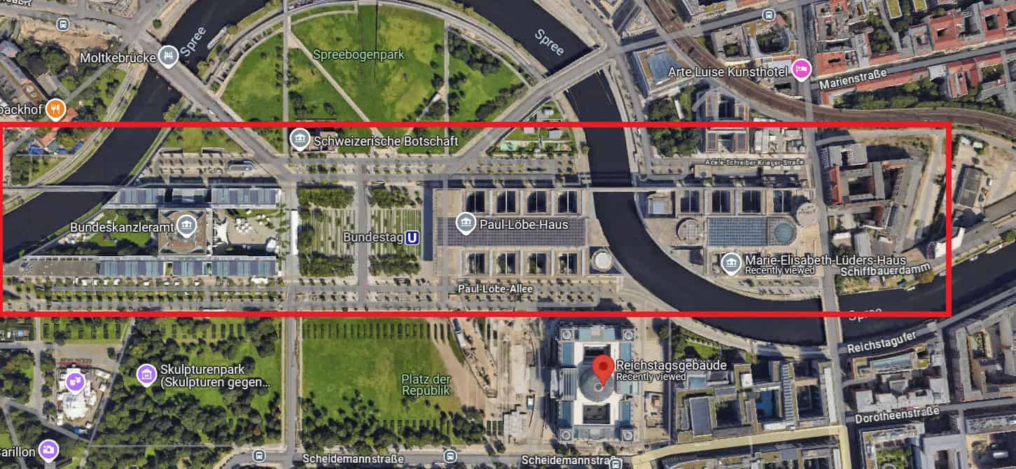
There are two pedestrian bridges crossing the river, the lower one for pedestrians and the upper one for government staffers.
The bridges, the two buildings, along with the Kanzleramt to the west, are all part of the Band des Bundes.
All 3 are all aligned on an east-west orientation, symbolically reuniting east and west when the federal government returned to Berlin after the fall of the GDR.
Inside of the Marie-Elisabeth Lüders Building is the Bundestag’s Berlin Wall Memorial.
Parts of the Berlin Wall have been rebuilt here to commemorate the division of the city along the former route of the Wall.
There is also a memorial book commemorating those who died at the wall.
You can visit everyday but Mondays from 11am until at 5pm.
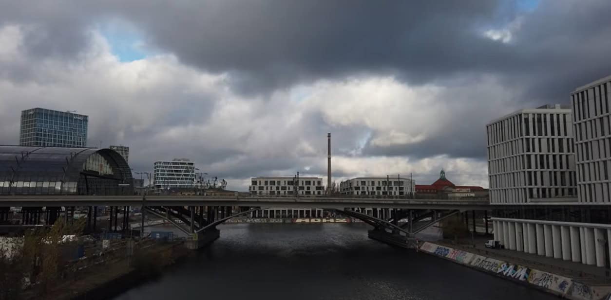
Marschall Bruecke
Now, we are headed to the other side of the Spree.
During the time of the Berlin Wall, travel restrictions between East and West Berlin applied not only to land crossings but also to waterway routes, including the Spree.
But the physical wall needed a bridge to cross.
It was on this bridge just ahead, the Marschallbruecke, where the Berlin Wall crossed from East Berlin to West Berlin (despite the bridge’s north-south orientation).
This image was taken from the top of the Reichstag looking toward the bridge.
We’ll join back up on the other side of the bridge.
Grundgesetz 49
And here we have an art installation by an Israeli artist, which consists of 19 glass panels, each about 3 meters in height.
On each of the 19 glass panels is one of the fundamental rights outlined in the original version of the German Basic Law from 1949.
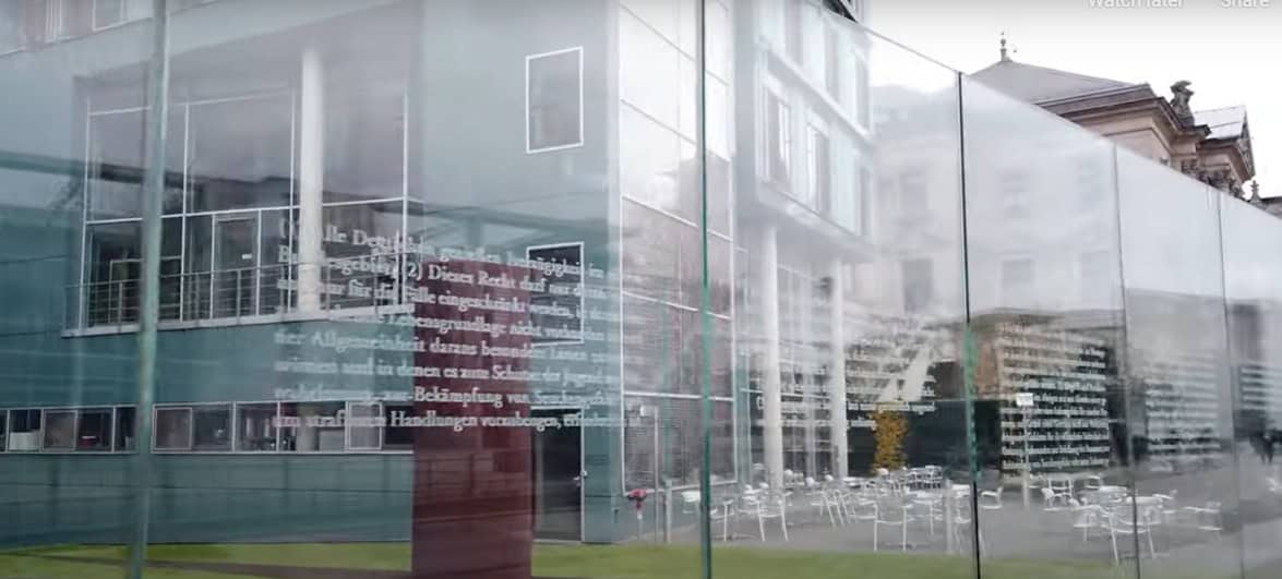
There is a recurring theme in both the architecture and the art around here, and that’s transparency.
Transparency is an important symbol considering Germany’s 20th-century history.
These glass panels are located in front of the campus of the Jacob-Kaiser Haus, which houses offices for the Bundestag.
These offices connect via underground tunnel to the Reichstag and other Bunestag buildings.
And a quick side note concerning World War II history.
Part of the campus includes the Palace of the Bundestag President.
Nazi politician Herman Goerring moved into this palace in 1932.
And one of the theories for the burning down of the Reichstag the following year is that Goerring allowed SS troops to the then little-known corridor to surreptitiously enter the Reichstag to set fire to it.
But that’s for another post.
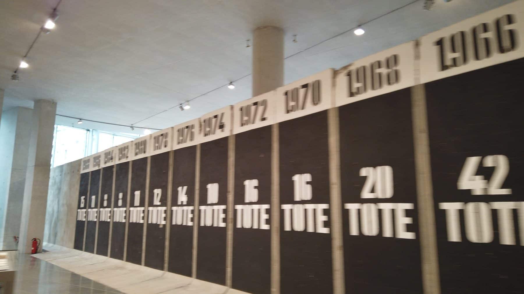
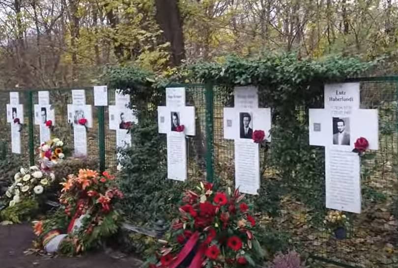
White Crosses
These white crosses are a memorial that were originally erected in 1971, on the 10th anniversary of the Berlin Wall’s creation to honor the refugees who lost their lives trying to escape from East to West Berlin.
Today, the crosses have names on both sides, except for one, which honors the unknown victims of the Berlin Wall, most of whom were shot or drowned.
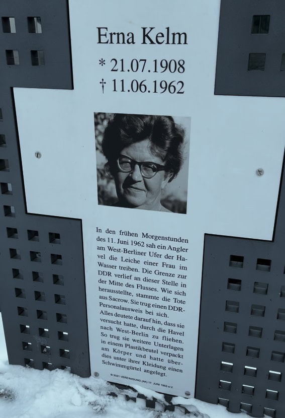
All in all, roughly 140 lost their lives in an attempt to cross the border fortifications inside of Berlin, and almost 600 in total trying to leave the GDR along its entire border.
On the other side of the Reichstag, along the road to the Brandenburg Gate is another set of white crosses, which we will see shortly.
Although these crosses originally formed an unofficial memorial, it appears that they are here to stay.
Monument of Solidarity
This small red brick wall was transported here as a gift of the Polish parliament to its German counterpart.
It’s a section of a larger wall located in the Port of Dansk.
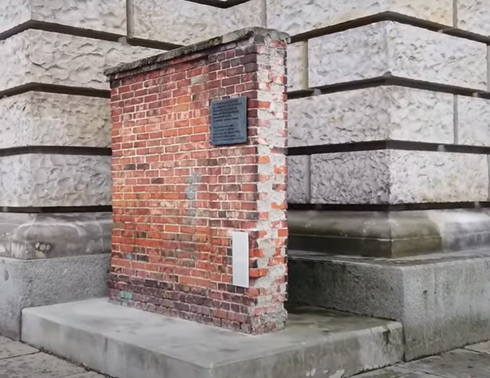
It’s from the very same wall on which Leck Valensa stood to start an illegal strike before forming the Solidarity Trade Union.
He was a leader in the pro-democratic movement that ended communist rule in Poland in 1989.
Reichstag
The Reichstag Building houses the German Bundestag, the federal parliament of the German Republic.
The building was originally opened in 1894, just after German reunification, to house the Reichstag (what today is known as the Bundestag).
It housed the German Parliament until 1933 when a fire gutted most of the building. The parliament was dissolved by Adolph Hitler and the Nazi Party.
It was also severely damaged in the Second World War.
From the end of the Second World War and through the Cold War, the outer Berlin Wall passed right up to the front of the building.
While the Reichstag was fully inside of West Berlin, it was not feasible to be used for the parliament of the Federal Republic of Germany.
Neither was West Berlin. The capital was moved to Bonn.

The area around the Reichstag was frozen in time.
Following the reunification of Germany, the Reichstag Building was renovated under the leadership of British architect Sir Norman Foster.
His glass dome, which affords a 360 view of the city as well as a unique bird’s eye view of the plenary chamber down below, is the biggest draw for visitors.
I have a video that provides tips on visiting the Reichstag that I will link to in this video’s description.
White Crosses on Ebertstrasse
The white crosses that we previously saw along the River Spree are part of the official memorial to victims of the Berlin Wall.
Why there are two sets of crosses is still unclear to me.
The official memorial was moved here during the reconstruction of the government quarter following reunification.
It seems that when the official memorial was moved back to the river bank, this set of crosses stayed.
In case you wonder why such a barrier was built, it was built to stop the flow of refugees pouring out of the GDR.
In the summer months of 1961, roughly 20k people a month were fleeing to West Germany, the vast majority to West Berlin, where the border was comparatively lax.
By the time the wall was completed, it’s estimated that just over 3 million East Germans had already fled, causing severe worker shortages and brain drain.
The GDR government was compelled to act.
Brandenburg Gate
The Brandenburg Gate is arguably the symbol of Berlin.
This structure dates back to the late 18th century and is the only gate that survives from Berlin’s old customs wall.
Its name comes from the city of Brandenburg am Havel, which is where this road once led to.
I have a video on the Brandenburg Gate that I will leave a link to in the description.

After the construction of the Wall in 1961, the Brandenburg Gate was within the exclusion zone and inaccessible from West and East alike.
Following the war, it was one of several checkpoints between East and West Berlin, but was closed once the wall was finished.
As it could be seen from the West, the Brandenburg Gate became a symbol of the German partition during the Cold War and the desire of reunification.
East Berliners were also able to see the gate, but from behind the inner wall barrier.
In June 1987, during a visit in Berlin (West) the American President Ronald Reagan came here, to the Western side of the Brandenburg Gate, and said
And on November 9th, 1989, a crowd totalling in the thousands descended on the Berlin Wall in front of the Brandenburg Gate.
Now, we are going to continue to follow the Wall down its path along Ebertstrasse.
HOLOCAUST MEMORIAL
As I mentioned earlier in this walk, the area between the outer and inner barrier walls was occupied by guard towers, electrified signal fences, anti-vehicle barriers, and other elements, like the death strip.
This area between the walls has been known as no-man’s land.
And since the fall of the wall, this no-man’s land has been put to various uses, both commerical as well as for public memorials.
And here, just 300 meters south of the Brandenburg Gate is arguably the most consequential reuse of no-man’s land.
Officially, this is the Memorial to the Murdered Jews of Europe, however, it is more commonly referred to as the Holocaust Memorial. I have a blog post covering the memorial that is very informative.
Potsdamer Platz
We’ve now reached the point where the Berlin Wall’s route turns east.
Prior to WW2, Potsdamer Platz was Berlin’s Piccadilly Circus. The war leveled it.
The construction of the Wall sealed this famed intersection’s fate as a no development area until after the fall of the Wall.
And on Potsdamer Platz, you find these pieces of the outer Berlin Wall.
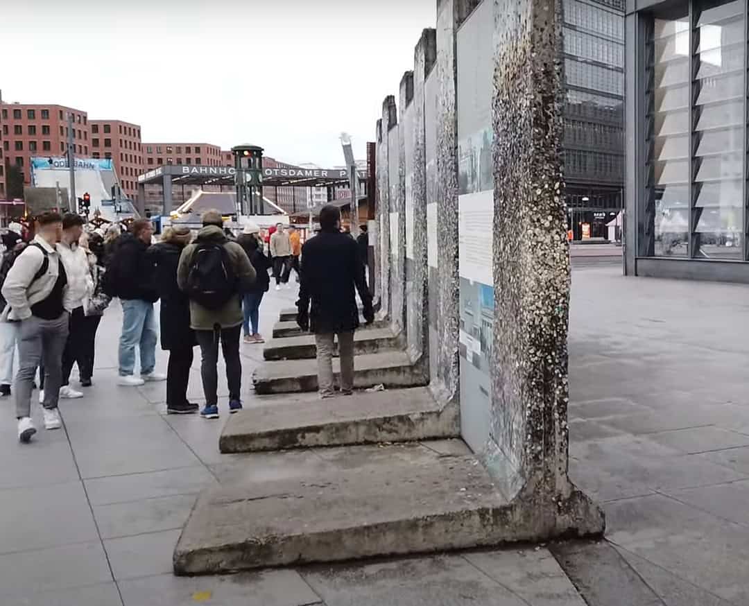
This memorial was originally intended as a temporary exhibit in 2005, but has been made permanent.
And, we are looking at the inside of the outer wall, so before the Wall fell, there certainly wouldn’t have been any graffiti on this side of the panels.
Today, Potsdamer Platz is home to the U2 Ubahn, several S-bahn lines, as well as several regional bahn trains.
During the GDR times, these stations were closed. The Ubahn didn’t operate.
And, only a few S-bahn lines passed through, making Potsdamer Platz on of Berlin’s renowned ghost stations.
There once were viewing stages set up here so that West Berliners and visitors could peek over the outer wall into the no-man’s land.
And this building here is home to Panorampunkt, a great option for an observation deck overlooking the city.
There is a piece of the Berlin wall called the Flying Wall, because it was helicoptered from the ground up to the observation deck.
I’ve shown you today mosly examples of the outer wall, but there are some examples of the inner wall still standing.
Let’s go check one of them out.
Leipziger Platz
We are now inside of Leipziger Platz where we find an example of the inner wall.
Like the inside of the outer wall, this would certainly not have been painted during the GDR days.
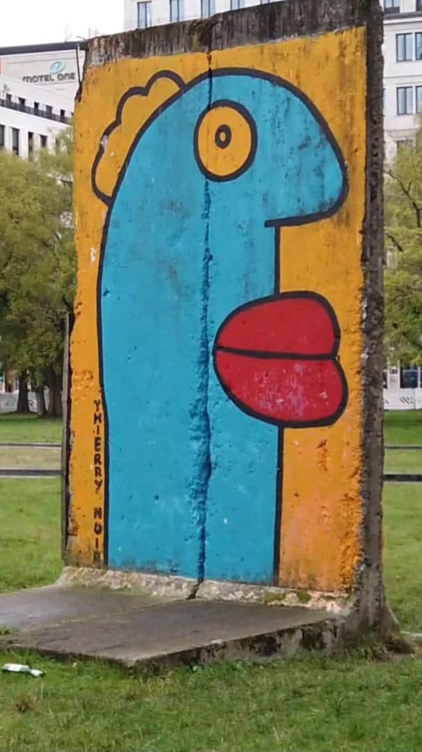
This particular work of art is the product of Thiery Noir, a French painter who moved to Berlin neighborhood of Kreuzberg in 1982 and started painting the outer wall there.
If you visit the East Side Gallery, then you will recognize that this piece resembles his larger piece there, titled Homage to the Younger Generation.
OK. Moving on.
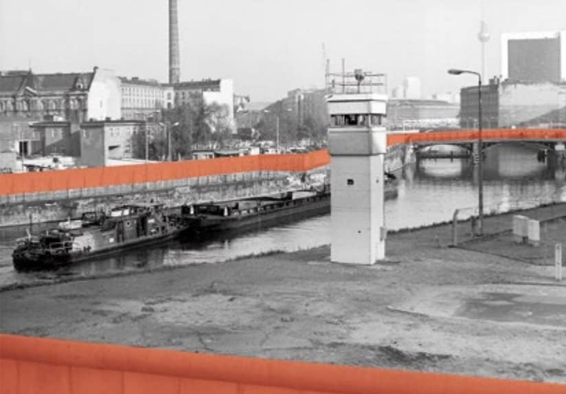
Observation Tower
This watchtower actually sat outside of the no-mans land, just behind the inner wall.
It was erected in 1969 and was one of the watchtowers built as part of the 2nd design of towers.
Like most components of the border fortification, the watchtowers were constantly improved upon and updated.
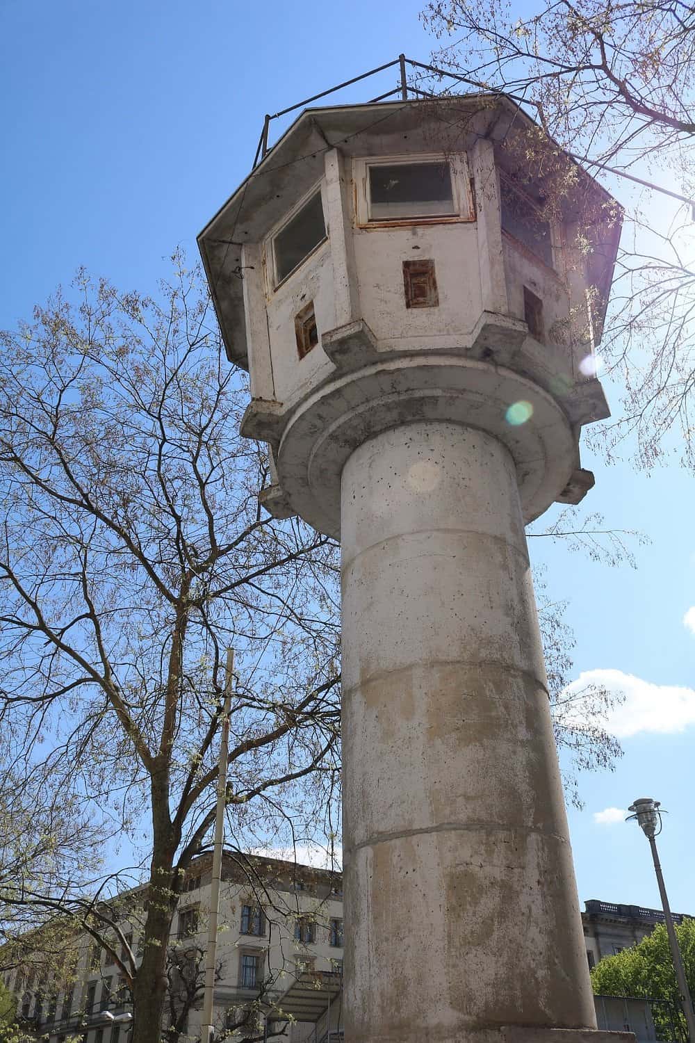
This model would eventually be replaced by the more boxy-style towers that are more connected with people’s imaginations when it comes to the Berlin Wall.
Now, back to the wall route.
As you walk south away from Potsdamer Platz, you will pass by the the German Federal Ministry for the Environment.
Like the Bundestag library building we previously saw, this government building is also built upon the former course of the outer Berlin wall.
And like its counterpart, it too has a piece of the wall on display on its ground floor.
Berlin Wall at the Topographie of Terror
We are now headed east from Potsdamer Platz on our way to Checkpoint Charlie.
And, here we have a 200 meter long section of the outer wall.
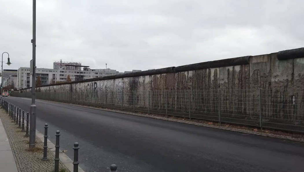
Aside from the East Side Gallery, this is the longest still standing section of the Berlin Wall.
This side faced no-man’s land, and as mentioned previously, there would have been no graffiti on this side during the Wall’s heyday.
Today, it is used as a wall for an exterior exhibit of the Topography of Terror, a museum located on what once was the headquarters of the SS and other organs of the Nazi state security services.
The museum covers the attrocties committed by these entities and is a must visit for new visitors to Berlin.
But we are going to stick to the Cold War era on this tour, but for our next stop, we are going to head behind the interior wall for one important stop.
House of Ministries
This enormous building on our left that we are walking along today houses the German Finance Ministry.
It originally housed the Nazi’s Ministry of Aviation headed by Herman Goering and is one of the few Nazi administrative buildings to have survived the war.
During the GDR days, this was the headquarters of the House of Ministries, where the decisions of the East German government were put into practice.
And, it’s here you will find an amazing 18-meter-long mural that was finished in 1952.
It consists of porcelain tiles from the Saxon region of Germany and presents cheerful depictions of agrarian, industrial, and artistic life under socialism in East Germany.
But happy days did not last long, as a workers’ strike the following year quickly turned into an open revolt involving millions of protestors throughout the GDR, which reached the doors of House of Ministries.
The protest was violently put down by East German and Soviet military and police forces, with an estimated 125 people killed or executed.
Today, the forecourt is a memorial to this 1953 uprising, with a glass-covered, pixelated, elongated photo of the demonstrators, all in full view of the mural.
Trabi World
OK. Back on our route to Checkpoint Charlie
On the left is Trabi World.

Trabi is the nickname for Trabant, the iconic East German tin can car that most citizens needed to wait at least 10 years to acquire.
You can rent one here or take part in a Trabi Safari, a guided tour through Berlin where you drive your own vehicle as part of a larger group.
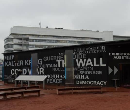
Checkpoint Charlie
We are now at Checkpoint Charlie, and on our left side is the Wall Panorama.
The Wall Panorama is a 360-degree theater that shows everyday scenes of the West Berlin neighborhood of Kreuzberg on a random autumn day in the 1980s.
It’s a look into a world that no longer exists on either side of the barrier.
Checkpoint Charlie was Berlin’s best-remembered crossing point between the communist East and the American sector of West Berlin.
The two lesser-known American sector crossing points were Checkpoint Alpha and Checkpoint Bravo.
It was here that a tense standoff between American and Soviet tanks almost ignited World War 3.
Believe it or not, the standoff started because of the opera.
Well, it’s a bit more complicated than that, but the short version is that the East German government wanted to exert it’s authority over the border in Berlin.
The border post, sandbags, and warning signs are all replicas.
And with the adjacent fast food restaurants and tick-tack souvenir shops, it’s often dismissed as a tourist trap.
But many find the location worthy of a visit, and there is plenty to experience.
There is a museum that covers the checkpoint, the Cold War, escapes to the West, and more.
There’s also the Black Box exhibit with 16 media stations, a small movie theater, documents, and original objects to demonstrate the East-West conflict that dominated the international political arena after World War II.
There’s also the Wall Panorama, which shows scenes of East and West Berlin on a random autumn day in the 1980s.
All three have ticketed entries and will take some time to get through.
If you are short on time or money, then spend some time browsing the Photo Gallery, 320 informational panels that include 175 large-format photos accompanied by written narratives.
The gallery focuses on three themes: the daring escape attempts at the border crossing, information about other memorial sites, and lastly the dramatic tank showdown.
End
And that’s it for this walking tour.
A couple of videos should be showing up on the screen shortly. I hope that you enjoy them.
And, if you enjoyed this walk, please share this post and give this video a thumbs up and consider subscribing to my channel.
Again, check out the description below for links to some of the other videos that I mentioned during this walk.
You’ll also find links to my walking tours.
Until next time. Tschuess!