In New Orleans, trolleys are called streetcars, and their image is iconic to the Crescent City.
The streetcar system, which is operated by the New Orleans Regional Transit Authority (NORTA) is cheap and easy to navigate and is used by both locals and tourists alike.
This post demonstrates how to ride the New Orleans streetcars with tips on choosing the right ticket, seeing the best sights, and understanding the streetcar’s history.
It's brought to you by us, your local tour guides from Tours by Foot New Orleans.
We ride the streetcars every day to get to work and answer our guests' questions about them on every single tour.
And, in the video below, Andrew, one of our tour guides, explains it all.
We also used some of the tips given by members of our popular NOLA Travel Tips Facebook group to help write this guide.
- Lines and Map
- Fares + Passes
- Tips on Riding the Streetcar
- Where Can You Go?
- A Streetcar Named Desire
- Other Things to Do in NOLA
There are currently 5 streetcar routes: the Riverfront; St. Charles; Canal (Cemeteries); Canal (City Park/Museum); and Rampart/St. Claude lines.
It’s important to know which line best serves your destination.
Though, many of you will likely be interested in the St. Charles Line to the Garden District, which you could use to reach our daily, pay-what-you-wish Garden District + Lafayette Cemetery #1 walking tour.
A simple New Orleans streetcar map

All but the historic St. Charles Ave. line are airconditioned, something visitors in the summer months will likely appreciate.
Rampart/St. Claude Streetcar
This line begins at Canal Street.
From here it runs through the downtown business district, near the Superdome, and along a quiet edge of the French Quarter, finally ending at the intersection of St. Claude Avenue and Elysian Fields Avenue.
This line runs from 6:00 a.m. to 12:00 a.m., seven days a week.
It makes stops at:
- St. Louis Cemetery #1
- Louis Armstrong Park
- The Treme
- Faubourg Marigny
- Frenchmen Street
St. Charles Streetcar
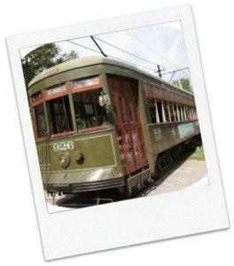
The Historic St. Charles Streetcar Line is the longest in the city and the oldest continuously operating street railway system in the world.
Travel along St. Charles Avenue and pass by beautiful mansions and live oaks then around the Riverbend past Audubon Park and Loyola and Tulane Universities to Carrollton at Claiborne Avenue.
If you want to catch the St. Charles Line heading toward Uptown/Garden District, then you’ll want to catch the car at the corner of St. Charles Avenue and Common Street in the Central Business District.
The cars on this line are vintage streetcars registered with the National Register of Historic Places and remain unaltered.
This means there is no air conditioning, and the cars ride with open windows.
Since the cars are registered landmarks, they are not all ADA-compliant.
That said, there are two cars on this line that are compliant for anyone who needs assistance.
This car runs all day and night, seven days a week. Riders can use their app to track these cars.
This line starts on Canal Street at Carondelet and travels through the Central Business District, Lower and Upper Garden Districts, and makes stops at:
- World War 2 Museum
- Garden District
- Lafayette Cemetery #1
- Audubon Park
- Audubon Zoo.
Be sure to download our free, GPS-enabled audio tour of the St. Charles Streetcar that you could take with you.
Here's a sample.
Click here to get the audio tour.
Riverfront Streetcar
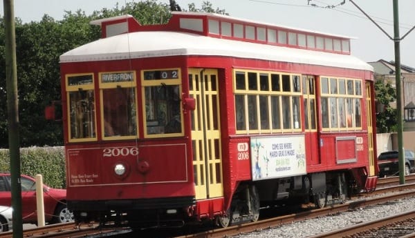
True to its name, the Riverfront line travels along the Mississippi River from the Ernest N. Morial Convention Center and the Aquarium of the Americas to the French Market.
This line, which operates vintage red streetcars, connects downtown to Marigny and Frenchmen Street.
This line runs from 5:30 a.m. to 11:30 p.m., seven days a week.
In addition to the French Market, this line can be used to reach:
- Faubourg Marigny
- Jackson Square
- Cafe DuMonde
- Riverboats
- Aquarium of the Americas
- Canal Street Ferry to Algiers
- Riverwalk
- Harrah's Casino
- Convention Center
- Shops at Canal Place
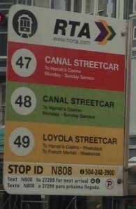
Canal Streetcar - Cemeteries
There are 2 routes for the Canal Streetcar Line.
This line services Canal Street from the riverfront to several historic cemeteries at City Park Avenue.
This line runs from 5:15 a.m. to 3:00 a.m., seven days a week, with special hours on holidays and parade days.
Canal Streetcar - City Park/Museum
This line begins at the Mississippi River at Harrah’s Casino on Canal Street and follows the Cemetery line up to Carrollton Avenue where it turns right and heads through Mid-City ending at City Park.
This line runs from 6:15 a.m. to 1:00 a.m., seven days a week, with special hours on holidays and parade days.
JAZZY PASS AND FARES
The New Orleans Streetcar is an affordable, easy way to navigate your way through the Crescent City.
A one-way ride on the streetcar costs $1.25, and an additional $0.25 to transfer from one line/car to another.
If you wish to take unlimited rides on the Streetcar, we recommend purchasing a Jazzy Pass.
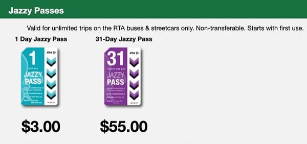
Jazzy Passes are available for 1 or 31 days.
For a single day's unlimited use, you can purchase a one-day Jazzy Pass online or on any New Orleans Regional Transit bus or streetcar for $3.
Just let your driver know you would like a day pass.
31-day ($55) pass must be purchased online or at a Jazzy Pass Ticket Vending Machine.
All passes usable on the streetcar also apply to New Orleans city buses.
You can find a Jazzy Pass vendor with the following map:
Passes can also be purchased online from the Regional Transit Authority (RTA) store, and you can have them shipped to you.
Since this method takes more time, we don't recommend it unless you're living in the area.
We recommend using the Les Pass app because you can download it onto your smartphone for free and use your phone as a pass.
This app also provides access to information about where to find streetcars, buses, and ferries, as well as details about route closures.
If you're just looking for tickets, you can find ticket vending machines with the map below. These machines are cash only.
It is important to know that exact change is required when purchasing one-way and single-day passes from your streetcar driver.
Drivers do not issue change. Any change due will be printed on a ticket card, which you can use for your next streetcar ride.
Norta.com (http://www.norta.com) is the best resource for streetcar maps and schedules.
With the exception of the St. Charles line, all New Orleans streetcars (and buses) are accessible to wheelchair users and others with disabilities at a reduced rate of $.40.
For details, see NORTA’s website (http://www.norta.com/Accessibility/Streetcars).
NOTE: The bus lines recently changed. If you're using the Les Pass app, it will have up-to-date and accurate information. Alternatively, you can also check their new bus routes here.
HOW TO RIDE THE STREETCAR
Streetcar lines generally have stops every two or three blocks along their routes.
On all NORTA maps, streetcar pickup locations are denoted with a streetcar icon, bus stops with a bus icon.
In person, you can spot the nearest pickup location by looking along the line itself for the words “CAR STOP” written vertically on an orange sign.
All you need to do is stand near the sign and the driver will stop for you.
Once you’re on board, it’s best to stay alert, since stops are not always announced (your driver might call out major stops, at their own discretion).
So if you don’t know your way around, your best bet is either to keep one eye on the map or to speak with the driver when you get on board.
Just mention where you’re going, keep within earshot, and the driver will let you know when you’re arriving.
When you hear your stop announced, or when you see it coming, just pull the cable over the seats to request a stop.
At the end of a line, all passengers disembark, and you have to pay a new fare or use a transfer to get on again going the other way.
THINGS TO SEE WITH THE STREETCARS
The various streetcars pass through very different parts of the city.
Below are a few of the highlights from each route, as well as some useful links.
Just about every line either stops at, starts from, or runs near the ferry terminal on Canal Street, where you could catch the ferry to visit the historic Algiers Neighborhood.
Riverfront Line
If you’re staying in the business district or on Canal Street, the Riverfront line is a great way to expedite the trip to the lower part of the French Quarter and beyond – Café du Monde, the French Market, or Frenchmen Street.
St. Charles Line
Before we tell you what to expect, we want you to be aware of our free, GPS-enabled audio tour of the St. Charles Streetcar that you could take with you.
Here's a sample.
Click here to get the audio tour.
The St. Charles line is one of the city’s major sightseeing destinations.
It can get crowded – so it’s a good idea to go early in the morning or around sunset.
From the edge of the French Quarter, it passes through the Warehouse/Arts District, where you can access the National World War II Museum or the Ogden Museum of Southern Art, and then into the uptown area.
Most visitors disembark in the Garden District – usually at Washington Avenue.
Here, you can for a walk among the neighborhood’s mansions, stop at Lafayette Cemetery #1, or through the shops and restaurants of nearby Magazine Street.
However, the Garden District is just the beginning of the most residential and visually impressive part of St. Charles Avenue.
This part continues until around Tulane and Loyola Universities and Audubon Park and Zoo.
If sightseeing is your main aim, this is a good point to stop and turn back.
Soon after this, the streetcar turns onto Carrollton Avenue, a more commercial street with a variety of restaurants.
Canal Street Lines
With the two Canal lines, it’s more about the destination than the journey.
There are a few great spots along the way – like Chickie Wah Wah, a Canal Street bar with excellent nightly music.
But the main attractions are the namesakes of the two lines.
The Cemeteries line is an option for exploring New Orleans’ above-ground cemeteries on your own, rather than with a guide.
The last stop on the Cemeteries line places you near fourteen different burial sites – from Holt Cemetery, a potter’s field with homemade memorials, to Metairie Cemetery, a huge, opulent necropolis for New Orleans’ wealthiest former residents.
You might want to read our guide to New Orleans Cemeteries.
The City Park/Museum line finishes just outside of City Park – an enormous green space containing the New Orleans Museum of Art, a sculpture garden, an amusement park for kids, a botanical garden, and lots more.
Check out our self-guided tour of City Park.
Rampart/St. Claude
Beginning at the Union Passenger Terminal, this line is a boon to travelers arriving by train or bus and looking to connect to nearby hotels in the business district and the French Quarter.
For those staying in this part of the business district, near the Superdome, it can also be a great way to reach parts of the French Quarter and beyond.
Rampart Street is the quiet side of the French Quarter, relatively, but you’ll find a growing nightlife along it – see here for some suggestions for a bar crawl.
Its endpoint on St. Claude Avenue falls near another cluster of bars and the St. Claude Arts District.
Lastly, the folks at Thrillist have put together a brilliant map (https://www.thrillist.com/drink/new-orleans/new-orleans-streetcar-map-map-with-bars-near-every-stop) of the streetcar system with bars located near the stops.
While you can’t bring a drink onto a streetcar, this map can still help you plan a great pub crawl – a $3-day pass is the perfect substitute for a designated driver.
A Streetcar Named Desire – Streetcars and History
Much of the fame of the New Orleans streetcar comes from its association with the Tennessee Williams play A Streetcar Named Desire.
And while the film adaptation was shot almost entirely on Hollywood soundstages, it nonetheless was key in giving many viewers an idea of New Orleans’ ambiance.
When the play was published in 1947, streetcars ran all over the city.
When Blanche, the protagonist, arrives in New Orleans, she takes a streetcar named Desire, transfers to another called Cemeteries, and steps off at Elysian Fields – impossible directions, but using the names of real streets and transit routes.
The real Desire Streetcar ran through the French Quarter, passing along Bourbon Street in one direction and Royal Street in the other, making its way to and from Desire Street in the neighborhood now called the Bywater.
But in 1948, the year after the play’s publication, the Desire line was replaced with a bus, as were most of the city’s streetcars over the course of the 1940s-60s.
Today, only vestiges of this old comprehensive system remain – if you’re attentive, you can see rails along the streets in many parts of town, or sometimes just parallel cracks in the concrete where rails were paved over.
Because of this widespread removal, the St. Charles Streetcar was for many years the only one in the city, surviving thanks to its status as a monument and the interest of visitors.
The Riverfront Streetcar was added in 1988, followed by others, with the latest line opening as recently as 2017.
A modern-day Blanche Dubois, taking a train into the city and working her way toward her sister’s address on Elysian Fields Avenue, would take a streetcar named Rampart/St. Claude – a bit less romantic than what Williams wrote.