Kreuzberg is named after the hill with the cross ("cross mountain") where this tour ends It is a Berlin district that has enjoyed more and more popularity.
Kreuzberg can be divided into east Kreuzberg, more unkempt and rich in immigration (the former SO36 postal code also gives a nickname to the area), as well as west Kreuzberg, the more trendy, bohemian part with the Bergmannstrasse.
If you can't take part on a walking tour, take this self-guided tour to get an overview of the main highlights.
Start your Kreuzberg walking tour at U-Bhf Warschauer Strasse (A). Take the U1 across Oberbaumbrücke to Schlesisches Tor (B) and walk westwards on Köpenicker Strasse.
View the full Kreuzberg walking tour map
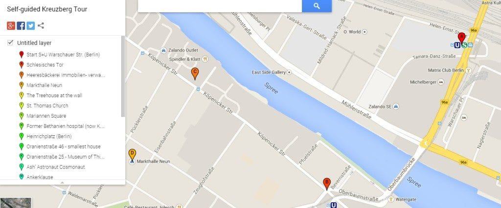
The yellowish brick building at the corner of Köpenicker Strasse and Brommystrasse (C), the former Heeresbäckerei, in Köpenicker Str. 16/17 was historically used as a bakery, mill, and storehouse for military provision bread or zwieback.
It was built in 1805 under Prussian rule and was conveniently closely located near the river Spree, so supply was easily transported via ship.
Today the building is used as office space and loft apartments.
Walk down Pücklerstrasse to reach Markthalle IX (D) which is one of the 14 (former) Berlin markets.
On Fridays and Saturdays, the market is open from 10am-6pm and is one of the more interesting places to try out specialties of the Berlin street food scene.
The Treehouse at the Wall - also called Guerilla Garden (E) - is located in the traffic island of Bethaniendamm.
During the separation of East and West Berlin the tree house was located in the middle, the so-called No-man's Land, because the area where it stood was supposed to be East German territory, but in the rush overnight and maybe to ease the construction, the Berlin Wall was built somehow imprecise.
The area was not used by either side, so technically it was then located in West Berlin.
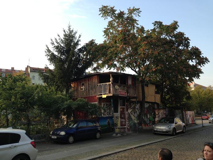
The area was inhabited in 1983 by Turkish immigrant and father of six Osman Kalin who started building the hut as well as a little vegetable garden.
Back then he had some trouble with the East German authorities who suspected illegal activity (e.g. building a tunnel underneath the wall).
Back in the day, you could see Osman sitting in his yard waving back at by-passers. Now one of his sons tends the garden.
View the full Kreuzberg walking tour map
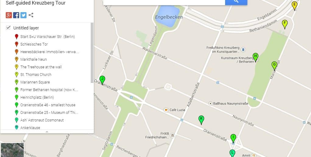
The St. Thomas Church (F), built in 1865-69, was one of the biggest evangelical churches of its time which seated up to 3000 churchgoers.
")
The Eastern parts of the church were destroyed during WWII and had to be rebuilt. If you walk around it, you will reach Mariannenplatz (G), named after Princess Marianne of Prussia.
The park is a popular hang-out and location for public soccer viewings, or street and family festivals.
If you look around you’ll see the former Bethanien Hospital (H). In the mid-1800s, a well-known German poet and writer Theodor Fontane (who wrote the ballad John Maynard) worked here as a pharmacist (his other profession next to writing).
Today the building is the Künstlerhaus (artist house) which is occupied by artistic or cultural institutes or other non-profit initiatives.
Walk down Mariannenstrasse until you’ll reach Heinrichplatz (I).
This is Oranienstrasse, a street named after the Dutch royalties of Oranje, filled with bars, restaurants and the famous SO 36 Club, the home of punk rock music of the 70s where David Bowie and Iggy Pop went to.
Oranienstrasse 46 (J), which houses an art space today, is the smallest house in the area with 48m2 (517sqf).
It was built in 1864 and filled the plot between the two neighboring houses. At Oranienstrasse 25 houses the Museum of Things (K) which is a really a historic collection of fascinating or hilarious things of really anything that fits into a glass cabinet.

Walk down Mariannenstrasse and don’t miss the piece of street art by Frenchman Victor Ash called the Ash Astronaut Cosmonaut (L).
The cultic Ankerklause boat bar (M) with a nautical theme and a great hang out during the summer.
On Tuesdays and Friday afternoon the Maybachufer Market (N) is the place for the popular Turkish Market where vendors sell produce, food, or garments.
Take a walk along the Planufer of the Landwehrkanal (O), the canal that runs parallel to the river Spree, and take a look at the many beautiful building facades.

The Grimmstrasse (P), named after the fairy tale Brothers Grimm and the Fontanepromenade (Q) (named after the German author) are beautiful residential streets separated by a green-space and therefore called twin streets.
At the Südstern (R) where 7 streets come together, you’ll notice the neo-Gothic church with its 90m tower that dates back to the years 1894-97 when it was built.
At Südstern you have reached Bergmannstrasse (S) which was named after the great landowning family Bergmann in 1837.
At the end of the 19th-century, many buildings were housed by working-class families.
Today Bergmannstrasse is one of the most popular and lively streets in the district with its many cafes, bars, bistros and the Marheineke Markthalle (T), a great indoor food and supply market.
View the full Kreuzberg walking tour map

In 1975, a couple days before the elections, CDU-party politician Peter Lorenz was kidnapped by terrorist movement June 2nd and held captive in a side street called Schenkendorfstrasse (U) in number 7.
South of Bergmannstrasse is also the Chamissoplatz (V), a block with beautiful and well-preserved 19th-century building facades.
Climb up Victoriapark (W) or often called Kreuzberg to get a beautiful view of the city.
This urban park has an iron cross designed by Schinkel (a famous Berlin architect) on top of the mountain commemorating the liberation wars of Prussia against Napoleon.
The park is famous for its artificial waterfall, but since the summer of 2014, the water pump needs to be repaired. Nevertheless, it’s still worth to climb up just for the view itself.
End: At Victoriapark your closest subway stops are U-Bhf Mehringdamm (U6, U7) if you are heading northeast of the park, or subway stop Platz der Luftbrücke (U6) is located southeast of the park.
Approximately 2.5 - 3 hours
+++Check out our self-guided tour of Berlin Friedrichshain as well. +++